


The accumulation predicted for tonight's snowstorm has been reduced from 4-8 inches to 3-6, but heavy snow and freezing rain is expected to wreak havoc on the roads with low visibility and a slick surface.
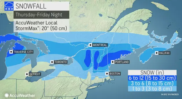
In fact, an Accuweather map actually shows Rochester, as ususal, right on the line between 3-6 and 6-12, so residents should be prepared for as little as three inches or as much as a foot.
Given the amount of pileups in the Greater Rochester during last week's dusting, motorists should take care to drive defensively during this week's storm, safety officials advise.
Moderate to heavy snow is expected begin around 7 p.m. tonight and continue on and off for 24 hours. The storm will begin with flurries that can be expected around 5 p.m.
The Greater Rochester area and southwest Maine are both expected to see significant snowfall.
Today's high will be around 40, but Friday's won't get much above freezing.
Friday's snow could linger well into the evening with flurries lasting as late as 9 p.m.
During last Thursday's storm Rochester Police responded to 10 motor vehicle accidents between 8 a.m. on Thursday and 8 a.m. last Friday, according to Rochester Police Capt. Todd Pinkham. Most were runoffs or minor fender benders with no serious injury.
Meanwhile, New Hampshire's Division of Homeland Security and Emergency Management urges residents and visitors to take action ahead of the storm.
Officially, DHS said Strafford County is under a Winter Storm Warning from 7 p.m. tonight till 7 p.m. on Friday.
A Winter Storm Warning means take action; confidence in the winter storm's impact is high and the storm is imminent or ongoing.
"Take action now to keep you and your family safe," said HSEM Director Robert Buxton. "Stay informed by listening to local weather reports. Have a plan in case an emergency does happen. Avoid traveling if possible. If you must travel, make sure your car's winter emergency kit is ready."
Other winter weather reminders:
· Visit ReadyNH.gov to learn more preparedness tips to help you and your family stay safe.
· Monitor National Weather Service radio or broadcast weather reports to keep track of changing conditions.
· Consider working or schooling from home so that crews can safely clear the roads.
· Slow down and move over for emergency vehicles.
· Never crowd the plow.
· Clear all snow and ice off your car, including your roof before traveling.
· Bridges, overpasses, and exposed road areas are the most prone to slippery conditions.
Accuweather material was used in this report