


Forecasters say the Greater Rochester area will be hit by a major nor'easter that is expected to bring with it 12-18 inches of snow and strong winds that could lead to whiteouts and widespread power outages.
"This is going to be an intensifying storm that will produce a lot of wind, which raises concerns for blowing and drifting snow, power outages and blizzard conditions in some areas," AccuWeather Chief Meteorologist Jonathan Porter said.
After a mostly sunny day today, Friday will start off cloudy with flurries beginning around 9 a.m. and continuing on and off throughout the day and evening.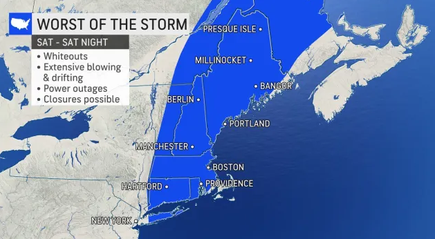
The nor'easter will begin ramping up around 7 a.m. on Saturday, with snow continuing unabated into the wee hours on Sunday, which will end up partly sunny and cold.
The impending storm, which will develop off the coast of the Carolinas late this week, could rapidly strengthen enough as it moves northward along the East Coast into the weekend to be dubbed a bomb cyclone. A bomb cyclone, or bombogenesis, occurs when the central pressure of a storm crashes by 0.71 of an inch (24 millibars) or more within 24 hours. The plunging pressure will cause air to rush into the center of the storm -- just like a giant vacuum. The high winds will pull in copious amounts of moisture, helping to enhance precipitation.
The combination of winds frequenting 40 mph or greater along with heavy snow will reduce the visibility to 1/4 of a mile or less for several hours, triggering blizzard conditions in portions of New England including Rochester.
The storm has the potential to shut down airports such as Manchester Airport and Logan International Airport, and could lead to scores of flight cancellations in New York City, Philadelphia and Washington, D.C. Heavy snow rates between 1 and 3 inches per hour along with extensive blowing and drifting snow will create extremely dangerous travel conditions. Snow drifts of several feet could occur in open areas. The storm is likely to maintain that intensity for a period of 8-12 hours, making it difficult to impossible for crews to keep up with roadways. Motorists who venture out could risk becoming stranded.
Winds on the backside of the nor'easter will usher Arctic air throughout New England, the central Appalachians, the mid-Atlantic, the Midwest and Southeast regions.
Accuweather material was used in this report